 "The journey not only broadens the mind, it shapes the mind"...
"Il viaggio non soltanto allarga la mente, le da forma"...
Bruce Chatwin
"The journey not only broadens the mind, it shapes the mind"...
"Il viaggio non soltanto allarga la mente, le da forma"...
Bruce Chatwin
ven
21
giu
2013
Oda al Verano
Verano, violín rojo,
nube clara, un zumbido de sierra o de cigarra te precede,
el cielo abovedado, liso, luciente como un ojo,
y bajo su mirada, verano, pez del cielo infinito,
élitro lisonjero, perezoso letargo,
barriguita de abeja, sol endiablado,
sol terrible y paterno, sudoroso como un buey trabajando,
sol seco en la cabeza como un inesperado garrotazo,
sol de la sed andando por la arena,
verano, mar desierto,
el minero de azufre se llena de sudor amarillo,
el aviador recorre rayo a rayo el sol celeste,
sudor negro resbala de la frente a los ojos en la mina de Lota,
el minero se restriega la frente negra,
arden las sementeras, cruje el trigo,
insectos azules buscan sombra, tocan la frescura,
sumergen la cabeza en un diamante.
Oh, verano abundante, carro de manzanas maduras,
boca de fresa en la verdura, labios de ciruela salvaje,
caminos de suave polvo encima del polvo, mediodía,
tambor de cobre rojo, y en la tarde descansa el fuego,
el aire hace bailar el trébol, entra en la usina desierta,
sube una estrella fresca por el cielo sombrío,
crepita sin quemarse la noche del verano.
P. Neruda
lun
18
feb
2013
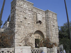
Basilica of St Francis and frescos/La Basilica di S Francesco e gli affreschi

English below
Hai mai visitato questa meraviglia di arte e pittura?
La Basilica di S Francesco di Assisi rappresenta per me, insieme alla Cappella Sistina di Roma e la Cappella degli Scrovegni di Padova, uno dei pezzi imperdibili che meritano essere visitati almeno una volta nella vita.
La costruzione della Basilica di Assisi iniziò dopo la morte di S Francesco ed è l’insieme di due chiese: la Basilica inferiore costruita per ospitare le reliquie del Santo ed i pellegrini che si recano in sua visita e quella superiore il cui utilizzo originale era quello di ospitare le riunioni ufficiali con un trono riservato al Papa.
Questa Basilica forma parte del patrimonio dell’umanità dell’Unesco dal recente anno 2000.
L’incredibile bellezza e quantità di affreschi attribuiti al Giotto, a Cimabue ed altri maestri dell’epoca rende queste due chiese un museo di pittura unico e davvero impressionante, per non parlare di una delle maggiori collezioni di vetrate artistiche d’Italia.
Nel Settembre del 1997 la Basilica, come l’intera città ed il centro Italia furono colpite dal forte terremoto che causò ingenti danni ai pregiatissimi affreschi, oltre alla triste morte di 4 tecnici che si trovavano all’interno della Basilica proprio per valutare i danni della scossa avvenuta la notte precedente, chi si dimentica di quelle immagini terribili!
La Basilica rimase chiusa alle visite per 2 anni ed il colossale lavoro dei restauratori che dovettero recuperare, classificare, dividere i milioni di frammenti e ricomporre gli affreschi andò avanti per 9 anni fino all’Aprile del 2006 anno della re inaugurazione della Basilica superiore. Visitare le 2 Basiliche oggi è una esperienza da brivido se si tengono in conto, oltre alla straordinaria bellezza degli affreschi, il peso della storia, l’immane lavoro svolto ed il risultato stupefacente. Da non perdere!
(video sul lavoro di ricostruzione)
http://www.youtube.com/watch?v=OTz7AFp7Z5c
Have you ever seen this masterpiece of arts and paintings?
The Basilica of St Francis of Assisi represents for me, together with the Sistine Chapel in Rome and the Scrovegni Chapel in Padua, a must see at least once in a lifetime.
The Basilica construction started right after St Francis died and is composed of two churches: the lower Basilica, built to house the relics of the saint and the pilgrims who come to visit them and the upper one, the use of which was to hosting official meetings, equipped with a papal throne.
The whole Basilica is part of the Unesco humanity heritage since recent year 2000.
The amazing beauty and quantity of frescoes attributed to Giotto, Cimabue and others famous painters of the period, is turning the place into a unique and really impressive paintings museum not to mention the stained glass collection, one of the biggest in Italy.
In September 1997 the Basilica, together with the whole city of Assisi and the central part of Italy, suffered a very strong series of earthquakes which caused extensive damage to the prized frescoes as well as killing 4 people which were checking damages of the previous night quake inside the Basilica, who can forget those terrible images!
The Basilica was closed to visitors for 2 years and the colossal work to which restorers were subjected to collect, divide, classify millions of fragments first and to recompose the frescoes after, lasted 9 years ‘till the re opening in April 2006. Visiting the site now is a real touching experience if you keep in mind nor only the beauty of the two Basilicas but the history, the amazing work done and the impressive result. Not to be missed!
(the video, in Italian, shows the reconstruction work)
http://www.youtube.com/watch?v=OTz7AFp7Z5c
dom
17
feb
2013
Castelluccio di Norcia and the flowering/La fiorita di Castelluccio di Norcia

English below
Castelluccio di Norcia, nel comune di Norcia, Parco Nazionale dei monti Sibillini, oltre 1400 metri di altitudine, ai piedi del monte Vettore, è uno dei centri abitati più alti dell’Appennino.
La spianata di Castelluccio, chiamata normalmente “pian grande” consiste in una area pianeggiante di circa 15 kmq di estensione, teatro di grandi eventi come la controversa partita di calcio da guinness dei primati con due squadre di 100 giocatori ognuna, oltre al famoso concerto di Claudio Baglioni nel 1995.
Famosi in tutta Italia sono i tartufi e funghi porcini della Valnerina ed i salumi e formaggi di Norcia che danno il nome alla “norcineria”, il monte Vettore ed lo spettacolare lago di origine glaciale di Pilato a più di 1900 mt e le pregiate lenticchie di Castelluccio ma forse in meno conoscono una delle più spettacolari meraviglie naturali che ogni anno portano migliaia di visitatori ed amanti della natura a fare visita a questi luoghi.
A partire da Maggio fino a Luglio inoltrato infatti lo splendido spettacolo della fioritura invade e rende questa vasta pianura un mosaico di colori con variazioni di tonalità che vanno dal giallo ocra al rosso.
La festa della “Fiorita” si celebra nelle due ultime domeniche di Giugno e durante queste settimane i colori cambiano in base alle tipologie di fiori ed i loro tempi di fioritura.
Lo spettacolo è davvero incredibile e impossibile da spiegare e consiglio veramente a tutti di andare a vederlo di persona, vale veramente la pena anche per provare dei buonissimi prodotti locali.
Non esistono date precise visto che tutto dipende dal clima e dai differenti tempi di sbocciatura ma esiste, oltre al sito ufficiale:
http://www.castellucciodinorcia.it/italiano/fioritura.htm
una webcam da dove è possibile seguire gli sviluppi e programmare quindi la visita per godersi dello spettacolo nel pieno del suo splendore:
http://www.umbriameteo.com/infometeo/index.php?task=webcam&id=1
Castelluccio di Norcia, located in the Norcia Municipality, Sibillini Mountains National Park, at over 1400 meters on the sea level, at the foot of Mount Vettore is one of the Highest located villages in the Appennines mountains.
The plateau of Castelluccio, named “piangrande” (the big plateau), consists in a flat area measuring about 15 square kilometers, place of big happenings such as the controversial Guinness world record football match which had involved two teams of 100 players each but also the famous huge concert of Italian singer Claudio Baglioni in 1995.
Famous all over Italy are the “Valnerina” truffles and porcini mushrooms and especially the delicious cheeses and cured cold cuts which gave origin to the name “norcineria” (used in Italy to group these kind of products), also the Vettore mountain and the amazing glacial lake of Pilato at a height of more than 1900 mts rather than the fine lentils produced here but maybe less people know one of the most spectacular wonder of nature which punctually every year brings thousands of visitors and nature lovers in this place.
Starting from May throughout roughly mid of July the magnificent spectacle of flowering invades and turns this plateau into a mosaic of colors which goes from yellow ocher to red.
The “Fiorita” feast takes place on the last two Sundays of June and during these weeks, colors are changing according to the flowers type and their different flowering times.
This is an incredible spectacle, there are no words to describe it, I really suggest you to see it, is worth the journey to see it and have some delicious local food.
There are no exact dates to go there as it depends on the climate and different timing but apart from sites such as:
http://www.umbriatravel.com/Norcia/Norcia_and_its_Nature.htm
you can also check the webcam to being able to schedule your visit and enjoy the show at its best:
http://www.umbriameteo.com/infometeo/index.php?task=webcam&id=1
mer
13
feb
2013
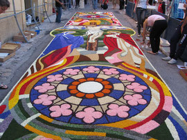
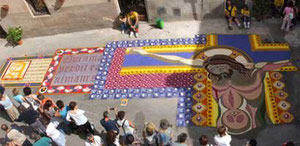
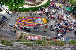
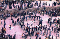
Spello and the "Infiorata"/l'infiorata di Spello

English below
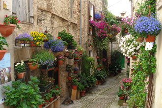
Spello è un piccolo e grazioso borgo dell’Umbria, in provincia di Perugia, adagiato ai piedi del monte Subasio famoso oltre per essere uno dei borghi più belli d’Italia, per la produzione del pregiato olio extravergine di oliva tanto da far parte dell’Associazione Nazionale Città dell’olio.
Tra gli avvenimenti che si svolgono in questo paese, due hanno a che fare con i fiori ed i colori:
la più famosa e storica “Infiorata” e quella più recente e meno conosciuta di “finestre, balconi e vicoli fioriti”, entrambe rendono il borgo ancora più straordinario e bello da visitare e si svolgono in primavera (la seconda manifestazione segue fino a Luglio inoltrato).
L’infiorata non è altro che la preparazione di spettacolari tappeti floreali e vegetali lungo il percorso dove passerà la processione del Corpus Domini.
Le origini risalgono al ‘900 quando una donna compose sulla strada una raffigurazione floreale che suscitò l’interesse di tutti e a partire da allora, ogni anno si compongono 1500 metri di stupendi tappeti che raffigurano varie immagini religiose o floreali.
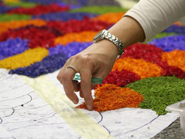
Questo avvenimento è il risultato di un lavoro che dura per tutto l’anno, dalla progettazione dei disegni a tavolino, alla raccolta dell’infinità di petali dai diversi colori e tonalità, alla mondatura, selezione e conservazione dei petali.
In primavera squadre di persone invadono le vallate dell’Appennino per raccogliere fiori ed erbe aromatiche mentre le anziane del paese si occupano di tritare le erbe e selezionare i petali ritrovandosi al fresco nei pianterreni.
Nel pomeriggio del giorno precedente la processione, le strade vengono chiuse al traffico e dopo aver predisposto le protezioni e l’illuminazione, inizia il gran lavoro finale, prima si disegnano sulla strada i modelli e poi si iniziano a depositare i milioni di petali che vanno a formare ogni tappeto.
Gli infioratori vanno avanti tutta la notte fino alle 9 del mattino quando le strade sono ricoperte da un unico tappeto policromatico e profumatissimo.
La particolarità dell’Infiorata di Spello è che non sono ammessi che fiori ed erbe aromatiche naturali, non trattati né contenenti polveri coloranti, si tratta di dipinti con pennellate di petali naturali di dimensioni da un minimo di 15 mq ad un massimo di 90 mq.
Col passaggio della processione, si conclude una esperienza di solidarietà, collaborazione, arte, cultura che ha impegnato almeno 2000 persone.
Se siete da quelle parti cercate di non perdere questa bellissima occasione, se passate in altri periodi date comunque un’occhiata a questo borgo così caratteristico e tradizionale!
Per il programma: http://www.infioratespello.it/
Spello is a small and beautiful village in Umbria, in the province of Perugia, lying at the foot of Subasio mountain famous, as well as being one of the most beautiful villages in Italy, for producing the fine extra virgin olive oil so much as to being part of the National Association of Oil production Cities.
Among the events which take place here, two have something to do with colors and flowers:
the most famous and historical “Infiorata” and the newly and not known “finestre, balconi e vicoli fioriti” (flowered windows, balconies and alleys), both are adorning the village making it even more beautiful to be visited in Spring (the second one begins in June and proceeds up to mid July).
The “Infiorata” consists in the preparation of spectacular floreal and vegetal carpets along the Corpus Domini procession rute.
The origins date back to ‘900 when a woman composed on the road a floral design that captured the interest of people, since then, every year they compose over 1500 mts of beautiful carpets representing religious or floral designs.
This event is the result of an entire year preparation, from the design of drawings, to the collection of million petals of different colors and tonalities, to the husking, selection and storage.
During spring, teams of people are invading the Apennines valleys to collect flowers and aromatic herbs while the elders gather in fresh locals to chop the herbs and select the petals.
In the afternoon of the day prior the procession, the interested road are closed to traffic, protections and lights are placed and the final huge work begins. First they draw models on the streets and following they begin to place the millions of petals in their position to create amazing colorful carpets.
The workers continue throughout the night up to 9 am when roads are covered up by a single polychromatic and very fragrant carpet.
The pecularity of the Spello Infiorata is that flowers and aromatic herbs are only admitted to be used and they cannot be treated nor contain colors powders, they create real paintings with colored petals measuring from a minimum of 15 sq.mts to a maximum of 90 sq.mts.
With the passage of the procession, the artistic, solidarity, cooperation and cultural experience which involved more than 2000 people can be declared over.
If you find yourselves in the area, try not to miss the experience while if you pass by in other times of the year, have a stop there to take a look to this characteristic and traditional village!
For the program: http://www.infioratespello.it/
mar
29
gen
2013
Re Alfonso "el sabio" y la tapa

English below
Sapete da dove ha origine il costume più tipico, famoso e diffuso di Spagna: "la tapa"?
Come sempre le teorie sono molte ma la più accreditata sembra essere la seguente.
L'ideazione e diffusione dell'usanza di servire una piccola quantità di cibo ogni qualvolta si chieda in un qualsiasi locale un bicchiere di bevanda alcolica come birra, vermouth, vino, si deve al Re Alfonso "il saggio", così chiamato proprio per questa invenzione che probabilmente molti spagnoli non conoscono esattamente e risalente al secolo XIII.
Il Re infatti allora cadde in malattia ed il suo medico gli prescrisse come cura, di bere piccoli sorsi di vino accompagnati da piccole quantità di cibo, tra un pasto e l'altro. Tale cura ebbe un effetto positivo per cui il Re decise di diffondere questa cura a tutti i suoi sudditi in modo che si mantenessero in salute. Tantopiù che in quei tempi gran parte del popolo lavorava la terra ed era abituata a fare la pausa a mezzogiorno ma, per povertà, il più delle volte solamente bevendo vino senza poter mangiare nulla. Questo comportamento chiaramente influiva sulla rendita lavorativa al rientro dalla siesta in quanto mangiando a stomaco vuoto, i contadini tornavano al lavoro ubriachi. Il Re decise quindi di promulgare una legge per la quale, qualsiasi taverna della Castilla dovesse servire una piccola quantità di cibo ogni qualvolta venisse ordinato un bicchiere di vino.
Questa usanza continua ancora solamente se vengono ordinate bevande alcoliche ed in alcune regioni della Spagna ciò si traduce in un vero e proprio pasto da quanto grandi sono le porzioni e per il fatto che servano dei veri piatti cucinati e non solamente olive o una piccola fetta di pane con qualche salume, come invece si usa oggigiorno in molti locali.
L'origine invece della parola "Tapa" deriva dal viaggio che lo stesso Re fece a Cadiz. Durante il viaggio infatti Re Alfonso X fece una sosta in una taverna sulla spiaggia, chiamata "el Ventorillo del Chato" ancora oggi aperta, battuta dal famoso forte vento. Il Re ordinò un bicchiere di "Jerez" e proprio quando stava per berne il primo sorso, una folata di vento alzò una nuvola di sabbia ed il cameriere prontamente coprì il bicchiere del Re con una fetta di prosciutto.
Il Re chiese allora al cameriere cosa stesse facendo e d il secondo rispose che aveva coperto il bicchiere con una "tapa" (tappo) per non far entrare la sabbia nel vino. Il Re divertito bevve il vino e mangiò il prosciutto e chiese un'altro vino accompagnato da un'altra tapa, i presenti seguirono tutti l'esempio del Re chiedendo la tapa per i loro bicchieri!
Do you have any idea where the most typical, famous and polar habit of Spain: "tapas" comes from?
There are different theories about, like usual, but the following one seems to be the most reliable. The credit of inventing and spread out the habit of receiving a small taste of food whenever asking for an alcoholic drink in any bar, is dued to King Alfonso "the wise", so called exactly for this episode dated from the XIII Century. An habit which probably many Spanish citizens experience everyday without exactly knowing the actual origin.
King Alfonso III became ill and his personal doctor prescribed him a peculiartreatment: to drink little sips of wine while eating very small amount of food, among the main meals. That cure gave a positive result and the King, after having completely recovered, decided to extend it to all subjects in order for them to maintaining good health. At that time, moreover, most of the people were peasants and they were normally having some rest at noon but, due to their poverty, only drinking wine without eating any kinf of food. This custom for sure was influencing negatively the production once they were back at work in the afternoon as most of them got drunk during the "siesta".
The King then decided to enact a law by which every tavern in Castille region had to serve small quantities of food per any glass of wine ordered by guests.
This habit is currently in use when you order an alcoholic beverage only and, in some regions of Spain, it turned almost to be a complete meal due to the generous portions of food served, not only olives or just a piece of ham and bread like most do nowadays.
The orgin of the word "Tapa" instead, comes from the journey same King Alfonso mede in Cadiz. During this journey the King stopped by a tavern named "el Ventorillo del Chato" located on a beach beaten by strong winds, still in operation today. The King ordered a glass of "Jerez" and when he was about to drink it, a wind gust raised up clouds of sand and the waiter quickly covered the glass with a slice of ham.
The King didn't understand what the waiter was doing and asked therefore why did he put the ham on top of his glass. The waiter answered then that he just put a "tapa" (cap) to avoid the sand entering in his glass. The amused King ate the ham, drank the wine and ordered another glass of wine accompained by another tapa, everyone there followed the King requesting wine and tapas for their glasses!
ven
25
gen
2013
The most famous 7 stars hotels in the world/I più famosi hotels 7 stelle

English below
Sapevate che l'unico hotel 7 stelle presente in Europa si trova in Italia a Milano?
Il Seven Stars Galleria, soprannominato il "settimo cielo", offre delle viste incomparabili all'interno della galleria Vittorio Emanuele II. Fra i vari servizi vanta quello di un maggiordomo privato che accompagna gli ospiti anche nello shopping.
Alcuni degli altri hotels 7 stelle sono:
- Emirates Palace di Abu Dhabi, con salotti, spa di lusso, limousines, campi da tennis e spiaggia privata di 1.3 km;
- Burj Al Arab di Dubai, ritenuto l'hotel più lussuoso al mondo è anche trà i 4 maggiori, con i suoi abbondanti 320 mt è diventato il simbolo di Dubai. Costruito su di un'isola artificiale è una vera meraviglia dell'architettura, offre una spiaggia privata, parco acquatico adiacente, eliporto e campo da tennis sul tetto e tra i ristoranti, il "Al Mahara" si trova sotto il cristallo dell'acquario marino;
- Pangu Seven-Stars Hotel di Beijing, disegnato dal famoso architetto C.Y.Lee, l'hotel ha la forma dell'animale più importante dello zodiaco cinese: il drago. Gli interni sono una combinazione di tradizione cinese, marmi italiani, carta da parati di seta ricamata a mano ed altri moderni stili europei;
Did you know that the only 7 stars hotel in Europe is actually in Milan?
The Seven Stars Galleria, known as "Seven heaven", offers unparalleled views inside the Galleria Vittorio Emanuele II. Among the services, boasts personal Butler services which also assists guest in their shopping.
Some of the others most famous 7 stars hotels are:
- Emirates Palace in Abu Dhabi, with its lounges, limousines, luxury spas, tennis courts and a 1.3 km private beach;
- Burj Al Arab in Dubai, reputed the world's most luxurious hotel, it is also the fourth largest in the world. With a height of 1,053 feet, the hotel has become the symbol of Dubai. It is a real architectural wonder and was built on an artificial island.
It offers a private beach, a waterpark, heliport and tennis court right on the very top of the building and among others, the Al Mahara restaurant located beneath the crystal water aquarium;
- Pangu Seven-Stars Hotel in Beijing, was designed by world famous architect C.Y.Lee., the hotel has the shape of the most powerful animal in the Chinese zodiac, the dragon. The interior design is a combination of Chinese classical tradition and contemporary European glamour, rare Italian marble and hand-embroidered silk wallpapers.
mer
23
gen
2013
The grapes and new years' eve/La notte di S.Silvestro e l'uva

English below
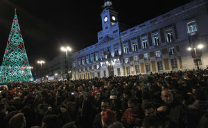
Una volta all'anno l'orologio del palazzo "de Gobernaciòn" nella porta del Sol di Madrid assume una importanza fondamentale quando la palla dorata inizia a scendere proprio prima dell'inizio delle scampanate della mazzanotte.
Questo orologio infatti segna la fine del vecchio anno e l'inizio del nuovo per il paese intero e per l'occasione la piazza si riempie all'inverosimile nell'attesa dei 12 rintocchi, forniti di spumante e degli immancabili 12 acini di uva.
La tradizione di mangiare un chicco d'uva per ogni rintocco risale all'anno 1909, anche se le teorie sono diverse.
In quell'anno il raccolto di uva fu eccezionale a tal punto che per festeggiare, la notte di fine anno venne offerta alla gente recatasi alla porta del Sol, una gran quantità di grappoli di uva.
Qualcuno lanciò la sfida di provare a mangiare un acino per ogni rintocco ed in molti accettarono di tentare l'impresa...non si sa quanti dei presenti riuscirono...gli acini erano provisti di buccia e semi, non come ora che si utilizza normalmernte uva preparata e già pulita.
Di sicuro le persone che diedero il via a questa tradizione devono aver passato un brutto momento: normalmente l'orologio impiega un totale di 36 secondi per effettuare i dodici rintocchi ma in quella occasione, per un mal funzionamento dell'orologio ciò avvenne in soli 17 secondi, una aggravante importante al già arduo compito!
Il mal funzionamento fu subito corretto e da allora la tradizione continua ed ogni anno migliaia di persone si recano all'appuntamento. Ormai tradizione trà i madrileñi è quella di festeggiare la "pre-uva" cioè recarsi alla porta del Sol la notte del 30/12 durante la prova generale delle campane, in questa occasione però vietato mangiare uva ma invece caramelle, arachidi, olive o qualsiasi altra cosa si voglia. Vista la moltitudine di gente del 31/12, è impossibile sentire le scampanate per cui importante sapere che non si tratta di un conto alla rovescia alla mezzanotte ma in realtà si tratta dei 12 rintocchi che effettua l'orologio al cadere di tale ora!

Once every year the main clock on top of "Palacio de Gobernaciòn" at Puerta del Sol square in Madrid assumes a fundamental importance when the golden ball lowers down to give start to the twelve bell strikes.
This clock, as a matter of fact, marks the end of the year and the beginning of the new one throughout Spain and for the occasion the square gets overcrowded while people is waiting for the twelve strikes, armed with champagne and 12 grape berries.
The tradition of eating a grape berry for each stroke dates back to 1909 even if there are various theories.
In that year the grape harvest was plentyful and to celebrate, they offerd a big quantity of grape bunches to the peolpe gathered in Puerta del Sol square to welcome the new year together.
Someone issued the challenge to eat one grape berry for every strike and many accepted to have a try...nobody knows how mwny succeded in the enterprise...the berries they were eating were not as nowadays peeled and with the seeds removed.
Famous is the celebrations of 1996 when peole who came for the celebrations had a very bad time: normally it takes 36 seconds to the clock to play the 12 strokes while in this particular occasion due to a clock problem, it only took 17 seconds, an aggravating factor ofno little importance considering tha already hard task!
The clock was fixed immediately and the tradition continued since then, every year thousands of people do not miss the appointment with the clock.
The new tradition among Madrid citizens is to celebrate the "pre uva", they gather in puerta del Sol square on December 30th during the rehearsal of the bells, to avoid confusion and enjoy the happening...but it brings misfortune eating grapes in this occasion, while most of them eat candies, peanuts, olives or any kind of staff but grape berries.
Due to the massive participation it is almost impossible to ear the bells on December 31st so you should know that this is not a countdown to midnight but actually the first seconds after midnight when the bells mark the 12 strokes!
lun
21
gen
2013
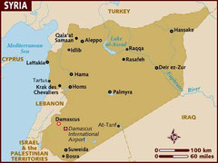
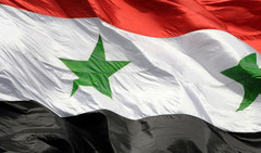
Syria, along the silk road/Sulla via della seta

English below
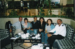
Parto per la Siria con un pò di tensione, non troppe aspettative e qualche preoccupazione, accompagno uno dei primissimi tours di un noto tour operator in questo paese, mi chiedono di annotare tutto e creare un taccuino di viaggio da poter passare ai colleghi nei futuri viaggi per avere dei riferimenti ed informazioni più dettagliate possibile dei luoghi.
Accompagno un gruppo di Presidi e Professori in pensione, gente colta e preparata che desidera da tempo di poter visitare questo splendido Paese.
Cerco di raccogliere più informazioni che posso ma certo i mezzi non sono quelli attuali, internet, Wikipedia, nè passaparola o amici già stati in questo posto…
L’aeroporto di arrivo è quello di Latakia, il tour di Siria e Giordania mi affascina da molto e da sempre avrei voluto conoscere la mitica Petra ma in quanto alla Siria ammetto essere abbastanza impreparato e comunque di certo non rappresenta una meta di turismo di massa ma al contrario di nicchia. Latakia, quando ricevo la telefonata, devo cercare nel caro vecchio atlante geografico.
L’impatto normale, località turistica costiera affacciata sul mediterraneo e frequentata da persone in cerca di relax e mare, un clima molto piacevole. La guida locale che ci accompagnerà ed illuminerà su questo Paese tanto misterioso quanto mitico, ci aspetta in aeroporto, si chiama Samaan, un ragazzotto di carnagione più chiara della mia ed occhi chiarissimi, parla un italiano perfetto tanto che tutti i viaggiatori credono sia lui l’accompagnatore italiano ed io la guida locale, sono già confusi.
Inizia il tour e mi si apre un mondo, chi non ha mai sentito parlare di “via della seta, Tigri ed Eufrate, Assiri e Babilonesi, Ittiti, Fenici, Antiochia, Bizantini, Crociate, oddio sembra essere nel libro di storia!
Samaan ci illustra tutto con una preparazione, familiarità e disinvoltura che rendono impossibile restare indifferenti, regge tranquillamente le continue, complicate ed elaborate domande del gruppo.
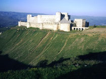
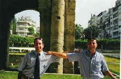
Via via si visitano il Crack des chevaliers, poco distante dalla oggi martoriata città di Homs. La fortezza risale al periodo delle crociate, la più grande fortezza realizzata dall’Ordine Ospedaliero oggi dichiarata patrimonio dell’umanità dall’Unesco. Indimenticabile anche il pollo mangiato nel ristorantino dei paraggi.
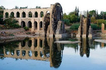
Il tour è tutto un crescendo, attraverso il vasto paesaggio di campi coltivati, montagne e deserto conosciamo Hama, citata nell’antico testamento con, lungo il fiume Oronte, le bellissime Norie; Apamea, luogo di passaggio e di unione tra Antiochia e Palmira sulla via della seta con il suo colonnato di 2 Km di lunghezza dove, sul lastricato, sono ben visibili i solchi incisi dalle numerose carovane cariche di chissà quali preziosi tessuti. Impressionante poter visitare il posto da soli, siamo gli unici viaggiatori presenti. Lungo la strada mi colpiscono i bambini che vanno a scuola con abiti militari perché in Siria, ci spiega Samaan, tutti sono chiamati a difendere la patria in caso di necessità.
Proseguendo verso la città di Aleppo ci si arrampica su per il massiccio calcareo per visitare il tempio di S.Simeone “lo stilita”, al confine con la Turchia, amiamo la sosta (diventata in futuro routine) dalle venditrici di focacce al peperoncino lungo la fredda strada di montagna con i loro forni di terracotta.
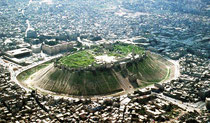
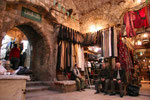
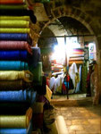
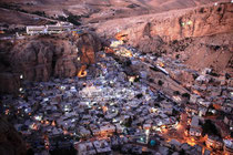
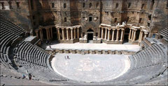
Aleppo, la città più popolata del Paese, terza maggiore città Cristiana nel mondo arabo, patrimonio dell’Unesco dal 1986 ma non solo, sede di uno dei suq più particolari ed antichi al mondo. Il bazar di Aleppo risale al XV secolo ed è il più grande suq coperto al mondo, ben 13 Km di gallerie, vicoli e intricate strade piene di banchi ricoperti di sete, stoffe di broccato, spezie, frutti secchi, il famoso sapone naturale all’olio di oliva, icone Bizantine, ed ogni sorta di manufatto, profumi e confusione ti catturano….fin tanto che passo il tempo a recuperare i viaggiatori persi qua e la. Prezioso come mai l’aiuto dei bambini locali che mi riportano al punto di incontro, di fronte all’ingresso della cittadella, i dispersi. Sono già catturato da questo Paese fantastico, di genti ospitali, sorridenti e davvero alla mano ma non ho ancora visto niente…la cittadella ci aspetta! Si tratta di una fortezza medievale arabo-islamica su di una collina artificiale di circa 50 mt di altezza con un fossato di 22 mt di profondità ed in grado di ospitare 10.000 persone in caso di assedio.

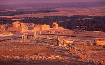
Samaan continua instancabile a trasmettere e contagiare con l’amore e l’interesse per questa terra. Si attraversa un tratto di deserto per raggiungere la splendida oasi di Palmira. In lontananza si intravede solamente la macchia di verde intenso nel mezzo del nulla, quasi impenetrabile, affascinante pensare alla visione che doveva rappresentare per i viaggiatori e mercanti che da giorni attraversavano il pieno deserto, fa davvero impressione. Una volta immersi tra le fitte palme si scopre la fantastica città rosa e visto l’arrivo nel tardo pomeriggio, prima di andare in hotel, sosta obbligatoria sulla collina del castello di Qala'at Ibn Maan che domina la città antica per godersi uno dei tramonti più spettacolari mai visti, sul complesso archeologico. Visitiamo Palmira il mattino seguente, la città si trova a 240 km a nord est di Damasco fu un importante centro di snodo tra oriente ed occidente per i carovanieri che attraversavano il deserto Siriaco e sostavano in questa meraviglia di oasi per rinfrancarsi e fare scorte di acqua prima di procedere verso la Persia, l’India e la Cina. Il santuario di Baal con il tempio dedicato al sole e alla luna, la via colonnata, le terme di Diocleziano, il teatro ed il santuario di Baalshamin, wow sembra di riuscire a vedere il brulicare di persone, merci, musiche in questa enorme città. Tra le colonne compaiono qua e la i ragazzini che chiedono l’elemosina e che pian piano si organizzeranno per vendere cartoline e piccoli souvenirs.
Da Palmira diretti attraverso il deserto fino a Damasco, con una breve sosta nella splendida Maalula, la città ferma nel tempo, poggiata sulle rocce dove si parla ancora l’Aramaico ed ci recitano il Padre Nostro in questa lingua.
Sono curioso ed impaziente di vedere la prossima città che rappresenta il Paese. Damasco è la città continuamente abitata più antica al mondo, è parte del patrimonio dell’Umanità fin dal 1979 con più di 125 edifici ed 8 porte di accesso alla città ancora conservate.
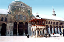
L'impressionante moschea degli Omayyadi sorta sui resti della cattedrale di S. Giovanni Battista e che ne conserva le vestigia. Il popolatissimo suq dove proviamo i deliziosi biscotti al pistacchio e sesamo ed il famoso gelato all’incenso, assistiamo allo spettacolo della danza della spada eseguita per noi proprio nella cornice dei i vicoli del suq ed il tempio di Giove, con gli uomini che eseguono svariate acrobazie accompagnati dalla musica tradizionale ed il fuoco e poi ancora i dervisci, una emozione unica. Dopo la cena sulla torre panoramica che ci mostra ai nostri piedi tutta l’immensità e spettacolarità di questo posto così pregno di storia si procede verso la città nera di Bosra.

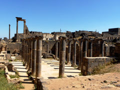
Devo dire che Bosra è la città che mi affascina di più, non solo per la bellezza ma per il contatto che si stabilisce con i locali, siamo assediati dalla moltitudine di bambini e per lasciare Samaan dare le sue spiegazioni, me li tengo tutti vicini, in disparte ed è qui che prendo le prime lezioni di arabo, mi insegnano parole per fare complimenti alle ragazze! Sono tutti così sorridenti e cordiali in questo posto così lontano da tutto. La città antica dalla sua parte non si lascia passare indifferente, fu capitale del regno Nabateo ma era già frequentata dal Faraone Thutmosi III, si trova vicino al confine Giordano e rappresentava una tappa privilegiata per le carovane di pellegrini che si recavano alla Mecca. Molto particolare in quanto costruita di basalto nero. All’interno del teatro romano perfettamente conservato e luogo di ritrovo degli abitanti nei giorni di festa, assistiamo e partecipiamo con la gente che si esibisce nei tipici balli e canti in cerchio, mano nella mano. Si visitano poi le terme, la via colonnata, la vasca del pellegrino, la Basilica di Bahira, l’ippodromo, la cittadella…
La visita della Siria volge al termine, dobbiamo procedere verso la Giordania ma le istantanee impresse durante questo viaggio, immagini di luoghi storici, paesaggi desolati, volti cordiali, il gran numero di bambini che ci hanno accompagnati ed aspettati con ansia ad ogni ritorno nei tours successivi, rincorrendo il bus mi hanno catturato per sempre.
Con questo mio racconto voglio rendere omaggio ad un Paese da molti sconosciuto e purtroppo spesso descritto come un Paese pericoloso e belligerante. Chiaramente non voglio fare riferimenti alla politica ma un popolo non è chi lo "governa"! Non sopporto il vedere le immagini di bombardamenti e morti, negli ultimi mesi si sono raggiunti numeri agghiaccianti mentre il mondo resta a guardare. Mi sento ferito ed impotente io con loro e voglio stringermi in un abbraccio con tutte le persone incontrate e non, sopratutto con Samaan con il quale ho lavorato più volte ed è nata una vera amicizia, ma anche Fida'a altra grande amica e la sua cultura, finezza e bellezza, la giovanissima e sorridente Suha e l’altrettanto preparato e simpatico Yasser, le splendide guide con le quali ho avuto l’onore di lavorare. Queste persone hanno fatto amare la loro terra a me e ai viaggiatori che ho accompagnato nei vari tours, sono i migliori ambasciatori del loro Paese e davvero, a parte Fida con la quale sono tutt'ora in contatto e vive in Italia, spero che tutti si trovino salvi, in salute e al sicuro ed il mio augurio è che prestissimo possano riavere la pace e tornare a fare questo lavoro che tanto amano e sopratutto, che queste immagini possano tornare ad essere quelle mostrate in televisione al posto di quelle di distruzione e disperazione che vediamo ora. Un abbraccio con tutto il cuore!
I leave for Syria with some stress, not many expectations and a bit concerned, I am leading one the very first tours of a known Tour Operator in this country, they ask me to write down as many information as possible and to create a travel notebook to pass to my colleagues to have some references on future journeys there.
I am traveling with a group of retired schools headmasters and teachers, cultured and educated people which had desired making this trip and getting to know this incredible country for a long time.
I try to gather as more information I can but certainly the means are not those current, internet, Wikipedia, word of mouth, friends already been there…
The airport of destination is Latakia, the tour in Syria and Jordan is really fascinating me and I have been willing to know the mythical Petra since a long time, but as for Syria I have to admit I am quite ignorant and among other things is not representing a very popular place to travel, Syria is indeed a niche destination instead. Latakia, when I receive the phone call, I have to look in the old dear atlas.
The initial impact is o.k., a tourist destination on the coast overlooking the Mediterranean and visited by people looking for relax by the sea, a nice warm climate. The local guide who is to drive and instruct us about this mysterious and legendary country, is waiting for us at the airport, named Samaan he’s a young man with clearer complexion of my and clear eyes, he can speak a very good Italian and guests get immediately confused, about who is the local guide and who the Italian tour leader.
The tour starts and a whole world opens up before me, who never heard about “the Silk Road, Tigris and Euphrates rivers, Assyrian and Babylonian, Hittite, Phoenician, Antioch, Byzantine, crusades, my God it’s like being in a history book!
Samaan keeps on explaining with a preparation, familiarity and easiness which makes it impossible to remain indifferent, stands quietly the continuous, complicated and elaborate questions from the group.
Little by little we visit the “Crack des chevaliers”, very close to the battered city of Homs today. The fortress dates back to the period of the Crusades, the largest one ever built by the Hospitaller Order, declared nowadays Unesco World Heritage Site. Also unforgettable the delicious chicken in the small restaurant of the area.
The tour is a crescendo, across the vast landscape of cultivated fields, mountain and desert, we got to know Hama, also mentioned in the Old Testament with, along the Orontes river, the beautiful Norias; Apamea, crossing point and connection between Antioch an Palmyra along the Silk Road with its colonnade of 2 km in length where the grooves made from the numerous caravans, charged with who knows what precious fabrics, are clearly visible. It’s impressive being able to visit the site alone, we’re the only visitors there. Along the road I'm struck by the children going to school wearing military uniform, we are told they are all called into service to defend the country in a danger situation.
Keeping on towards Aleppo we climb up onto the limestone mountain to visit St. Simeon “stylites” temple, close to the Turkish border, we love the stop along the cold mountain road (which became routine in the future) to the ladies making chili pepper breads with their clay owens.
Aleppo, the most populated city of the country, the third Christian city in the Arab world, Unesco World Heritage since 1986 and more, home to one of the world most ancient and unique bazaar. The suq in fact is dated back to the XV Century and is the biggest covered one in the world, almost 13 Km of tunnels, alleys and intricate streets with plenty of benches covered up with silks, brocade fabrics, spices, dried fruits, the famous natural olive oil soap, Byzantine icons, all sort of handicrafts, perfumes and confusion whisks you away…as much as I spend most of the time looking for the lost travelers. Thanks God groups of local children help me by accompanying those lost travelers to the meeting point right in front of the citadel entrance. I am fully captured from this magnificent country with such hospitable, smiling and genuine people even if I haven’t seen that much so far…the citadel is waiting! The medieval Arab-Islamic fortress was built on the top of an artificial 50 meters high hill with a 22 meters deep moat it is able to accommodate almost 10.000 people in times of siege.
Samaan tirelessly keeps on transmitting love and interest for his country. We cross a stretch of Syrian desert to get to the amazing Palmyra oasis. From a distance we can only see a huge dark green spot in the middle of nothing, it looks almost impenetrable, fascinating if you think about the effect he had to do on travelers and merchants which had spent several days crossing the desert. Once we cross the palm trees wall we discover the famous pink city and as we arrive in the late afternoon, before reaching the hotel, we proceed to the hill overlooking the entire city were the Qala'at Ibn Maan castle is located, to have an incredible view on the archeological complex during the most fascinating sunset I have ever seen. We visit Palmyra on the following morning, 240 km away north east of Damascus it once was a fundamental connection center between the East and West for the caravans crossing the Syrian desert and found this Oasis to rejuvenate and to stock up on water before proceeding to Persia, India and China. The Baal Sanctuary with the “sun” and “moon” temple, the colonnade, the Diocletian’s Baths, the Baalshamin’s theatre and sanctuary, wow I think I can see the swarming of people, goods, music in this huge city. Among the columns here and there young boys appear begging for some coins, they will organize later with postcards and souvenirs to sell.
From Palmyra straight thought the desert to Damascus, with just a small stop to see the fascinating Maalula, the city still in time, leaning on the rocks where they still speak Aramaic.
I am very curious and I can’t wait to see the next city which represents the entire country. Damascus is the most ancient continuously inhabited city in the world, declared Unesco World Heritage since 1979 with more than 125 historical buildings and 8 access gates. The impressive Omayyad mosque built on the ruins of St. John the Baptist’s cathedral which preserves the remains. The very populated bazaar where we taste the popular pistachio and sesame seeds biscuits and the typical incense ice cream, we witness the spectacle of the sword dance, performed especially for us and framed by the suq’s streets and the Zeus temple while men are performing various stunts, accompanied by traditional music, fire and also following the dervishes, a unique emotion. After having dinner on the top of the rotating tower showing the whole city at our feet with all the splendor and immensity of a place full of history, we proceed towards the city of Bosra.
I have to admit that Bosra is the most fascinating city to me, not only because of its beauty but especially for the relationship that is established with the local, we are besieged by the multitude of children and, in order to leave Samaan doing his job, I keep all of them aside with me and this is how I get the first Arabic lesson, they teach me words to impress girls! Everybody is smiling and so friendly in this such an isolated place. The ancient town, on the other hand does not go unnoticed, it was the capital city of the Nabataean empire but it was already known from Pharaoh Thutmose III, it’s located next to the Jordan border and was very popular among the pilgrims on their way to Mecca. Bosra is also very particular as it was built with black basalt stones, inside the very well preserved Roman theater, gathering place on holidays, we take part to the spectacular local people’s dances and choirs in circle, hand in hand. We visit the Baths, the colonnade, the tank of the pilgrim, Bahira church, the hippodrome, the citadel…
The visit of Syria ends here, we have to proceed to Jordan but the Images burned during this trip, are snapshots of historical places, desolate landscapes, friendly faces, and together with the large number of children looking after us and eagerly waited for us to come back on the next visit they capture me forever.
With my story I only want to pay a tribute to a country unknown to many and, unfortunately, often described as a dangerous and belligerent place. Obviously I don’t want to make references to Politics but a population is not those who govern it! I can’t stand the images of bombing and killing a Nation, on the last months they reached frightening numbers while the hole world’s only watching. I feel hurt and powerless with them and I really want to squeeze in a hug with all the people I met and those I didn’t, especially with Samaan with whom I worked several times and a friendship was born, but also with Fida’a, also very good friend and her culture, finesse and beauty, with the very young and smiling Suha and the equally prepared and nice Yasser, the splendid guides with whom I had the honor of working. These people made me and the visitors I was leading fell in love with their country, they’re the best ambassadors of their homeland and really, apart from Fida’a with whom I am still in touch as she lives in Italy, I hope they’re all safe and healthy and my wish is that they can have peace back very soon and get back to their beloved job and also these images can go back to being the ones shown on television instead of bombing and desperation ones. A warm hug from the bottom of my hearth!
ven
18
gen
2013
Madrid, el oso y el madroño

English below
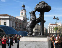
La statua dell'orso che si appoggia ad un piccolo albero di corbezzoli situato nella Porta del Sol giusto dove inizia la calle Alcalà, è un motivo che si incontrerà varie volte girando per Madrid, fa parte dello scudo della città e ne è il simbolo, come la lupa a Roma o l'orso di Berlino. Come forse un pò tutti i simboli araldici le sue origini sono abbastanza confuse.
Il primo emblema della città raffigurava una pietra focaia (selce) colpita ai lati da due martelli di acciaio che facevano uscire delle scintille. Il disegno era avvolto da un nastro con l'iscrizione in Latino: "sic gloria labore" (questa è la gloria del lavoro), la parola "paratur" (preparati) ed in basso le frasi: "fui edificata sopra l'acqua. Le mie mura sono di fuoco. Questa è la mia insegna e stemma".
Queste frasi si riferiscono al fatto che Madrid fu originariamente costruita su sorgenti sotterranee, le mura erano costruite di pietra focaia, il che produceva scintille al colpirle con frecce con la punta di metallo e che questo era il suo scudo. Nel 1202 con il Re Alfonso VIII l'emblema fu modificato con l'immagine di un orso che cammina su un campo d'argento con sullo sfondo la costellazione dell'orsa minore e la stella del nord che punta la coda dell'orso.
Ma perchè un orso?
La maggior parte della gente crede che il motivo sia il fatto che in quei tempi l'area intorno a Madrid era ricoperta di boschi abbondantemente abitati da orsi; alcuni sostengono che si tratti di una femmina di orso, simbolo della fertilità.
I manoscritti che si trovano negli archivi della città, confermano che si trattava di una femmina di orso.
In quanto alle stelle, esiste un vincolo tra la costellazione dell'orsa minore e l'utilizzo dell'orso come simbolo nello stemma della città. C'è pure chi sostiene che le sette stelle rappresentino le sette scuole di astronomia che esistevano già nel secolo X. Altri invece credono che le stelle rappresentino il cielo di Madrid conosciuto per essere sempre limpido. Con le controversie tra Chiesa e Stato, il disegno dell'orso passò dal camminare nel campo all'ergersi sulle zampe posteriori, come simbolo del dominio della Chiesa sui campi, ed appoggiarsi con le zampe anteriori su di un albero, rappresentando il dominio dello Stato sul legno e sulla caccia, il tutto circondato da una frangia azzurra che simboleggia il cielo e sette stelle che rappresentano l'orsa minore.
Va specificato che anche se si crede che l'albero di corbezzoli sia appunto un albero, in realtà si tratta di un arbusto non autoctono della zona di Madrid.
Perchè venne quindi scelto come emblema?
Si ritiene che in principio l'albero venne soltanto scelto come simbologia della conciliazione tra Chiesa e Stato e che in seguito un artista diede ai frutti il colore rosso soltanto per abbellire.
Curiosa è la storia che durante una epidemia in città che coincide con la visita di Re Carlos V, proprio questi venne contagiato e salvato grazie ad una cura ottenuta facendo bollire foglie di corbezzolo. Il miscuglio non solo salvò la vita del Re ma anche quella di molte persone in città e da allora l'albero viene identificato come un corbezzolo.
Nessuno è totalmente sicuro del vero perchè venne scelto questo albero a simbolo della città ma durante gli anni nonostante lo scudo della città sia cambiato svariate volte, l'orso e l'albero di corbezzoli sono sempre rimasti.
Nel 1554 Madrid passò allo stato di Città e venne aggiunta allo scudo una corona. Nel 1842 comparirono una corona civile a simbolo della guerra di indipendenza della città ed un drago che non si sa bene da dove ebbe origine. In una delle porte della città, esattamente la Puerta Cerrada, si dice che in precedenza apparisse un dragone. I due simboli restarono nello scudo per anni fino a che nel 1967 il comune di Madrid recuperò il disegno precedente con un orso nero appoggiato ad un albero con frutti rossi e circondato da sette stelle, il tutto sormontato da una corona.
Questo è il simbolo tutt'ora in uso nonostante in molti posti della città si vedano esposti esempi precedenti come ad esempio nelle entrate del parco del Retiro dove ancora si vede raffigurato il dragone.
The statue of a bear leaning on a corbezzoli tree located in Puerta del Sol square right at the beginning of Calle Alcalà, is a pattern you will find everywhere in Madrid, is part of the city shield and represents its symbol like the wolf in Rome or the bear in Berlin. A bit like all the heraldic symbols, its origins are kind of confused.
The first city emblem portrayed a flint stone hitted on the sides by two hammers which were producing sparks. The image was framed by a ribbon with the Latin words: "sic gloria labore" (this is the glory of the work), the word "paratur" (get ready) and beneath: "I was built upon waters. My walls are made of fire. This is my sign and emblem".
These sentences refer to the fact that Madrid was actually buit upon groundwaters sources, their walls were made of flint stones which produced sparks when hitted by arrows with an iron tip and this was the city shield.
In 1202 whith King Alfonso VIII the shield was modified with the image of a bear walking on a silver field onwards to the Ursa minor constellation and the North star pointing his tale.
Why a bear?
The majority of people believe the reason is dued to the fact that in the past Madrid was surrounded by forests populated by a large number of bears; some believe that the bear is a female bear, symbolizing ferility.
The manuscripts preserved in the city archives, are confirming this last hypothesis.
In regards to the stars, there is a connection between the Ursa minor constellation and the utilization of the bear as the city symbol. There's also who believe the seven stars are representing the seven schools of astronomy supposed to exist since X Century. Others believe stars represent Madrid sky known to be always clear. With the disputes between church and state, the representation of the bear went from walking on the field to stand on his hind legs leaning on a tree, as a symbol of the churh domain on the fields and the state one over wood and hunting, all surrounded by a light blue ribbon representing the sky and the seven stars for the Ursa minor constellation.
To be specified that though people believe that the corbezzoli tree is in fact a tree, it is actually a shrub which is not native of the area.
Why did they choose it as the emblem then?
It is believed that inicially the tree was only chosen as a symbolism of reconciliation between church and state and later, an artist painted the fruits in red only as decoration.
It's curious the tale about the plague in Madrid that coincided with King Carlos V, he was infected and saved thanks to a medicine obtained by boiling corbezzoli tree leaves. The cure didn't only save the King but the majority of citizens and was identified as a corbezzoli tree since then.
Nobody is absolutely sure about the real reason why this tree was chosen to symbolize the city but over the years, despite the shield suffered various changes, the bear and the tree always remained.
In 1554 Madrid passed to the staus of City and a crown was added to the shield. In 1842 also a civil crown to symbolize the city Indipendence war and a dragon which origins are unknown.
In one of the city gates, Puerta cerrada, they say a dragon was represented in the past. The two new symbols remained on the shield during years untill, in 1967, Madrid municipality regained the previous model with a black bear leaning onto a red fruits tree surrounded by seven stars and topped with a crown.
This is still the symbol nowadays even though somewhere in Madrid you can still find the previous symbols eg. on the Retiro park entrances where you can also see the dragon.
mar
15
gen
2013
Madrid km 0

English below
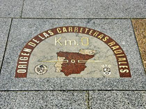
- Madrid è stata il centro politico del Paese dal regno di Filippo II nel secolo XVI, quando il monarca decise di convertirla nella capitale del regno. La corte reale era abituata a spostarsi di città le precedenti città del regno sono state Toledo, Valladolid, Burgos e Barcelona ma Filippo che aveva trascorso lungo tempo a San Lorenzo dell'Escorial, in un famoso palazzo-monastero che lui stesso aveva fatto costruire fuori Madrid, desiderava una nuova capitale nell'esatto centro geografico della Penisola Iberica. Madrid è più o meno equidistante da tutti i porti marittimi del paese e ciò significava potersi spostare facilmente verso tutti i punti, oltre che poter esercitare più facilmente il controllo delle varie regioni. Durante il regno di Filippo V si costruirono 6 strade principali che partivano da Madrid, da quì si stabilì che il punto 0 di partenza fosse la Puerta del Sol. Anticamente durante il regno di Carlo III, si assegnarono a queste strade numeri da I a VI preceduti dalla lettera "N" (per Naciònal) oggi sono tutt'ora chiamate allo stesso modo. Nel 1950 venne collocata la targa sul marciapiede del palazzo di "Gobernaciòn" conosciuto anche come casa reale delle poste, che indica il punto esatto dal quale si misurano la distanza chilometrica di tutte le autostrade nazionali spagnole. Quando si incontra una segnaletica stradale che indica ad esempio 100km, ciò significa 100km fino alla targa menzionata. Oltre al punto di partenza delle principali strade, la targa indicava il centro geografico di Madrid , nonostante nel 1978 si calcolò che l'esatto centro fosse un punto all'interno del museo del Prado mentre oggigiorno si calcola che tale punto sia nell'incrocio delle strade di Goya e Serrano mentre il centro esatto della penisola si trova in un posto chiamato Cerro de los Angeles, 10 km a sud di Madrid. Dalla Puerta del Sol si calcolano anche tutti i numeri civici delle strade della città ovvero, la numerazione ascende allontanandosi dalla piazza.
- Madrid is the political center of the country since the reign of Philip II in the XVI Century, when the monarch decided to convert it into the capital of the kingdom. The rolyal court was used to move from city to city, the previous reign cities had been Toledo, Valladolid, Burgos and Barcelona but Philip who had spent a long time in San Lorenzo del Escorial, in a famous palace-monastery which he had built himself outside Madrid, desired a new capital in the exact center of the Iberic Peninsula. Madrid is more or less equidistant from all Spain's harbours and this meant being able to move and easily control all regions. During Philip V reign 6 roads were built which started from Madrid, from here they decided that the starting 0 point was going to be Puerta del Sol square. Formerly, during Charles III reign, they assigned to these roads numbers from I to VI preceded by the letter "N" (as in Nacional) and they yet keep the same name. In the 1950's a plaque was placed on the "Gobernaciòn palace" path, also known as royal mail house, indicating the exact point where all national motorways are measured from. When you find a street sign indicating for example 100km, it means 100km to the plaque. Besides indicating the beginning of roads, the plaque was indicating the geographical center of the city, despite in 1978 they calculated the exact point was somewhere inside the Prado museum while nowadays they believe this point is at the intersection of Goya with Serrano roads and the peninsula center is in Cerro de los Angeles village, located 10 km south Madrid. From Puerta del Sol they also calculate Madrid streets house numbers, the numbering increases while you move away from the square.
mar
15
gen
2013
# 10 Kominato beach, Ogasawara Islands Japan
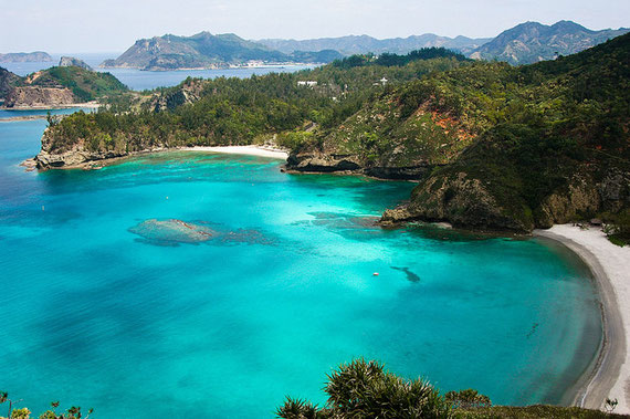
- Le isole Ogasawara, anche note come isole Bonin, sono un arcipelago di oltre 30 isole tropicali e sub-tropicali a più di 1000 km a sud della capitale Giapponese Tokyo. Il nome Bonin deriva dalla parola giapponese bunin che significa disabitato, oggigiorno solamente due isole sono abitate. Particolarità dell'arecipelago, nominato nel 2011 patrimonio dell'umanità dall'Unesco, è l'evoluzione singolare che flora e fauna hanno avuto in queste isole da sempre isolate da tutto il resto e per questo mitivo soprannominate le Galapagos d'oriente. Protette e raggiungibili solamente con una traversata di 26 ore, la visita dell'arcipelago è gestita ed organizzata dall'esercito. Alcune delle isole non sono visitabili dovuto alla presenza di residui bellici della II Guerra Mondiale. Le isole sono famose per le varie attività possibili quali l'osservazione di balene, il bagno con i delfini, immersioni, snorkeling, pesca e trekking.
- The Ogasawara Islands, also known as the Bonin islands, are an archipelago of over 30 subtropical and tropical islands, some 1000 km directly south of Tolyo Japan. Bonin is the common name in English from the Japanese word bunin, meaning uninhabited, nowadays only 2 islands are inhabited. Peculiarity of the archipelago, named on 2011 human heritage from Unesco, is the singular evolution that flora and fauna have had in these islands always isolated from all the rest and which gained, for this reason, the nikname Oriental Galapagos. Protected and only reachable by a 26 hours boat trip, visits to the archipelago are organized and ruled from the military force. In some of the islands access is forbidden due to the presence of World War II residues. The archipelago is famous for the range of activities you can practice such as whale watching, dolphin swin, scuba diving, snorkeling, fishing and trekking.
lun
14
gen
2013
#9 Whitehaven beach, Queensland Australia
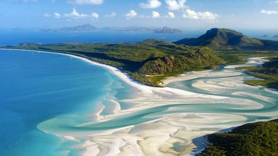
- Whitehaven beach è una spiaggia che si estende per 7 Km lungo l'isola di Whitesunday. L'isola è accessibile in barca dai porti turistici di Airlie beach e Shute Harbour oltre che da Hamilton Island. La spiaggia è stata premiata come la più pulita del Queensland nella competizione statale di spiagge pulite del 2008 di "Keep Australia Beautiful". Nel 2010 Whitehaven Beach è stata nominata dalla CNN la spiaggia eco-sostenibile migliore al mondo. Famosa per la sua sabbia bianca composta per il 98% di pura silice che le da questo colore bianco brillante. Visto che le rocce locali non contengono silice, si suppone che la sabbia sia stata trasportata fino alla spiaggia dalle correnti marine milioni di anni fa. A differenza della sabbia normale, questa non trattiene il calore e ciò rende comodo camminarci in un giorno di sole. La particolare finezza della sabbia è anche pericolosa per le attrezzature elettroniche mentre è particolarmente adatta per pulire gioielli. Anche questa isola è protetta e non vi si può pernottare.
- Whitehaven beach is a 7 km stretch along Whitesunday Island. The island is accessible by boat from the mainland tourist ports of Airlie Beach and Shute Harbour, as well as Hamilton Island. The beach was awarded Queensland's Cleanest Beach in Keep Australia Beautiful's 2008 Clean Beach Challenge State Awards. In July 2010, Whitehaven Beach was named the top Eco Friendly Beach in the world by CNN. Whitehaven Beach is known for its white sands which consists of 98% pure silica which gives it a bright white color. Local rocks do not contain silica so it has been suggested that the sands were brought to the beach via prevailing sea currents over millions of years. Unlike regular sand, the sand on Whitehaven Beach does not retain heat making it comfortable to walk barefoot on a hot day. This sand is also very fine, and can damage electronic equipment, although it is good at polishing up jewellery. This island is also protected therefore overnight is not permitted.
dom
13
gen
2013
#8 Fernando de Noronha, Natal Brasil
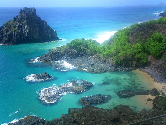
- A circa 350 km dalla costa di Natal (un'ora di volo), nord est del Brasile nel mezzo dell'oceano Atlantico si trova l'arcipelago di Fernando de Noronha, 21 fra isole ed isolotti di origine vulcanica. Si tratta di un complesso di spiaggie all'interno di una laguna dai meravigliosi toni turchesi, blu e verde smeraldo, spiaggie dorate. Una fauna marina tra le più ricche del Brasile, scogli, coralli e vegetazione primitiva. Dichiarato dall'Unesco patrimonio naturale dell'umanità nel 2001. La particolarità di questo arcipelago è che i flussi sono controllati (700 persona al massimo posso soggiornavici contemporaneamente nell'intero arcipelago) e sebbene diventino sempre più popolari si può godere delle bellissime spiaggie, delle piscine naturali, dei percorsi di trekking immersi nella natura, snorkeling, immersioni e surf quasi in totale solitudine. La vacanza va programmata in anticipo per poter riuscire ad accedere all'arcipelago.
http://www.ilhadenoronha.com.br/?gclid=CMDDptDQ5bQCFe3KtAodBkgARA
- More than 200 miles (one hour flight) off the coast of Natal, north east Brasil in the middle of the Atlantic ocean find place the archipelago of Fernando de Noronha, 21 betrween volcanic islands and islets. Is a beach complex inside a lagoon with astonishing blue, turquoise, emerald green colors and golden sand beaches. The marine life is among the richest of Brasil, rock, corals and primitive vegetation. Fernando de Noronha was decleared from Unesco a World natural heritage in 2001 . The peculiarity of this archipelago is that flowes are controlled (700 people at a time can overnight on the islands) and even if they're gettin more popular day by day you can still enjoy the beautiful beaches, natural swimming pools, trekking paths, snorkeling, diving and surf in almost complete solitude. You have to plan the holiday in advance to get the chance of entering in the achipelago.
http://www.ilhadenoronha.com.br/?gclid=CMDDptDQ5bQCFe3KtAodBkgARA
sab
12
gen
2013
#7 Illetes, Formentera Balearic islands
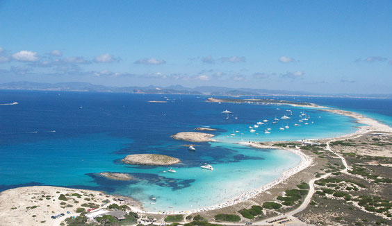
- Formentera è parte dell'arcipelago delle Isole Baleari e forma insieme ad Ibiza, il gruppo chiamato delle "Islas Pitiusas", dovuto alla notevole quantità di pini presenti nelle due isole. Fino a pochi anni fa entrambe, con i vari isolotti minori circostanti, appartenevano al Consiglio Insulare di Ibiza e Formentera che ha lottato e sicuramente contribuito a mantenere, Formentera in particolare, un'isola completamente natutare. le La spiaggia di Illetes si trova nella penisola del Trucador, una lingua di sabbia bianchissima all'interno della riserva naturale di Salinas la quale si protende verso l'isola di Espalmador. La spiaggia che si affaccia sull'altro lato del Trucador è quella di Levante. La particolare poseidonia locale che purifica l'acqua marina e la rende di questo colore cristallino è stata dichiarata nel 1999 dall'Unesco, Patrimonio dell'Umanità. Nonostante l'invasione di turisti durante l'estate, l'isola è protetta e le costruzioni controllate. Vista la conformazione prettamente pianeggiante (Sa Mola, la parte più alta si trova a soli 120 mt. slm.), i vari percorsi naturali ciclabili ed il poco traffico, è particolarmente indicata ad essere visitata tranquillamente in bicicletta.
- Formentera is part of the archipelago of Balearic Islands and named, together with Ibiza "Islas Pitiusas", due to the large number of pine trees on the two islands. Until a few years ago, these islands and the various smaller ones surrounding, were part of the Ibiza and Formentera Island Council which has fought and surely contributed to mantain, Formentera in particular, an entirely natural spot. Illetes beach is located in the Trucador peninsula, a natural and bright white sandbar in the Natural Reserve of Salinas north side, which reaches out to Espalmador island. The beach located on the other side of the Trucador is named Levante beach. The particular local posidonia filtrating the sea water and giving it this particular turquoise colour was declared in 1999 a world heritage from Unesco. Despite the mass tourist invasion during summer, the island is protected and construction's ruled. Due to the flat conformation of the island (Sa Mola, the highest part is only 120 mts. on the sea level), the numerous cycle paths and the lack of traffic, it is particularly indicated to be visited by bke.
ven
11
gen
2013
#6 Hamoa beach, Maui Hawaii
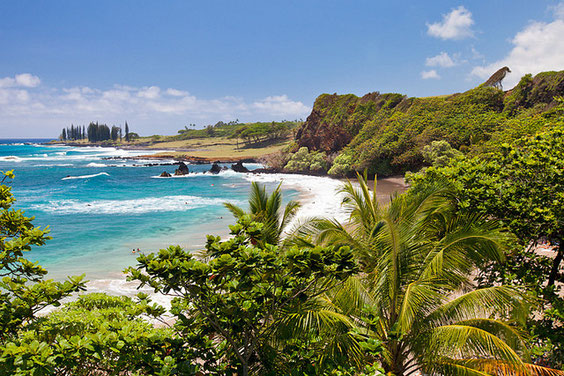
- Questa spiaggia a forma di mezza luna, di sabbia grigia (dovuta alla miscela di corallo e lava) in un paesaggio realmente tropicale è una delle preferite da chi vuole solamente prendere il sole, fare snorkeling o surf nella zona di Hana. la spiaggia misura circa 30 mt. per quasi 300 mt. di lunghezza e si trova proprio sotto una scogliera di lava nera alta più di 10 mt. Si tratta di una spiaggia non protetta ed aperta sull'oceano e la zona è spesso battuta da forti correnti. La parte sinistra della spiaggia è adatta allo snorkeling, essendo più calma.
- This half moon shaped, gray sandy beach (a mix of coral and lava) in a truly tropical setting is a favorite among sunbathers, snorkelers, and body surfers in Hana. The 100 foot wide beach is about 900 feet long and sits below 30 foot, black lava sea cliffs. An unprotected beach open to the ocean, Hamoa is often swept by powerful rip currents. The calm left side is best for snorkeling in the summer.
gio
10
gen
2013
#5 Isola di Budelli, Sardegna
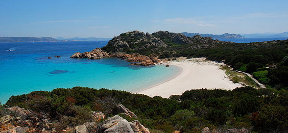
- La Spiaggia Rosa si trova sull'isola di Budelli, facente parte dell'Arcipelago di La Maddalena, ed è una meraviglia naturale nota in tutto il mondo, grazie anche allo straordinario effetto cromatico esaltato da Antonioni nel film Deserto Rosso. La Spiaggia Rosa di Budelli deve il suo nome alla presenza di una alta percentuale di bioclasti nella composizione sedimentaria delle sabbie. Questi bioclasti hanno origine soprattutto nella prateria a Posidonia oceanica e, dopo il loro disfacimento, vanno a depositarsi sul litorale grazie alle correnti di fondo. Per evitare il saccheggio di sabbia rosa da parte dei visitatori, dal 1998 la spiaggia è completamente tutelata ed è chiusa sia al transito che alla balneazione. Provvedimento che le ha restituito l'antica integrità estetica, riportandola ad essere un autentico capolavoro della natura, purtroppo solo da ammirare.
- The pink sandy beach is located in Budelli island offshore Sardinia island, is part of the archipelago of La Maddalena and is a natural wonder famous all over the world also due to the amazing chromating effect exalted by Antonini's "the red desert" movie. The Budelli pink beach owes its name to the high percentage of bioclast in the sedimentary sand compsition. Those bioclasts originate in the oceanic Posidonia prairies and, after their breakup thanks to the bottom currents, they settle on the coast. To avoid the looting of pink sand from visitors, since 1998 the beach is fully protected and closed both to transit and swimming. This mesure returned aesthetic integrity to the beach bringing it back to being the authentic masterpiece of nature, to be admired only.
mer
09
gen
2013
#4 Trunk Bay, St. John, US Virgin Islands
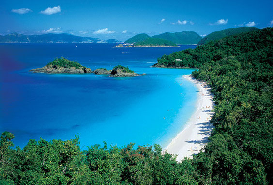
- Restiamo sempre ai Caraibi ma spostandoci verso est. Siamo nelle Isole Vergini, territorio Statunitense, ancora una spiaggia paradisiaca dove la esuberante vegetazione arriva quasi a tuffarsi nel mare cristallino. L'isola si trova all'interno del parco naturale delle Isole Vergini, quasi interamente circondate da barriera corallina e ricche di diversi percorsi sottomarini segnalati, per fare snorkeling ed immersioni nel rispetto della natura. L'accesso a questa spiaggia, votata da National Geographic e da Conde Nast tra le 10 migliori, è possibile solo su pagamento di un biglietto di ingresso a contributo della salvaguardia della stessa. Meravigliosa!
- Let's remain in the Caribbean just moving towards east. We're in the Virgin Islans, U.S. territory, one more heavenly beach where the exuberant vegetation almost dips in the crystal clear sea. The island is part of the U.S. Virgin Islands Natural Park, almost entirely surrounded fby the coral reef and rich with various submarines indicated paths, to snorkel and dive respecting nature. The access to the beach, voted one of 10 the best beaches in the world by National Geographic and Conde Nast, is only possible by paying a small entrance fee as a contribution to the park preservation. Amazing!
mar
08
gen
2013
#3 Pink sand beach, Harbour Island, Bahamas
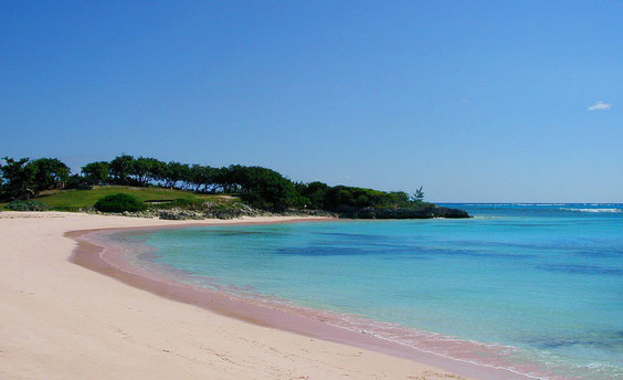
- Harbour Island, nell'arcipelago delle isole Bahamas è conosciuta come una delle più belle spiaggie rosa al mondo. Più di 2,5 Km di sabbia composta da minuscoli frammenti di coralli, conchiglie, roccia e carbonato di calcio derivante da piccoli invertebrati. Rinomata inoltre come uno dei migliori posti di immersione al mondo grazie anche alla "current cut dive" una corrente costiera che permette di percorrere circa 2 Km in 2 minuti! La spiaggia diventa spettacolare al tramonto, quando sabbia e cielo assumono lo stesso colore.
- Harbour island, in the archipelago of Bahamas is worldwide famous as one of the most beautiful pink beaches in the world. 1.5 miles beach composed by coral, shells and calcium carbonated fragments originating from small invertebrates. It's also renowned as one of the most beautiful diving places in the world thanks to the current cut dive, a shore current that displace you more than a mile in two minutes! The beach gets spectacular at the sunset when sky and sand became of the same color.
lun
07
gen
2013
#2 Maya Bay, Koh Phi Phi Lee Island, Thailand
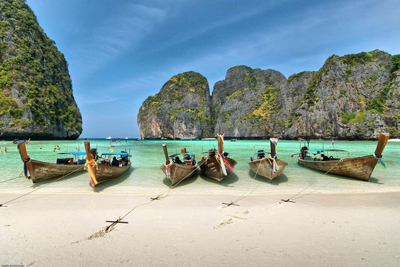
- Con una breve traversata di 45 minuti da Pukhet sarete trasportati nel paradiso tropicale. Parte del piccolo arcipelago delle isole Phi Phi, nel mare delle andamane, provincia di Krabi è stata resa famosa dal film The Beach (che l'ha anche rovinata con l'arrivo del turismo di massa) e devastata dallo tsunami del 2004, sta lentamente tornando al suo stato originario. L'isola si trova accanto alla maggiore Koh Phi Phi Don dove sono situate le strutture ricettive visto che la minore è solamente visitabile ed è vietato soggiornarvi. Sabbia incredibilmente bianca e formazioni rocciose da togliere il fiato che emergono dal mare turchese il quale circonda l'isola vi confermerà immediatamente di essere giunti in paradiso. Un peccato che si possa godere della stupenda spiaggia soltanto per poco tempo. Gran parte delle escursioni ti lasciano in mare nella parte posteriore dell'isola, c'è da fare un percorso tra le palme per avere la spendida visione della bai., Portatevi una macchina fotografica subacquea o qualkcosa per proteggere la vostra..io non ho foto!
- Just a short boat ride from Phuket will transport you to the tropical paradise. Part of the small archipelago of Phi Phi islands, in the Andaman sea, Krabi district become famous from the movie The Beach (which has also ruined it with the arrival of mass tourism) and devasted from 2004 tsunami, is slowly getting back to the original condition. The island is located very close to the major Phi Phi Don where all infrastuctures find place as the minor one can only be visited and is prohibited staying there. Fine, white sandy beaches and breathtaking rock formations rising from the vivid turquoise waters that surround the islands will instantly confirm you've arrived in paradise. A pity that you can only enjoy this amazing place for such a short time. Most of the excursions will drop you right on the water, in the back side of the beach, you have to have a walk among the palm trees to suddenly have the megnificent vision of the entire bay. Remember to bring an underwater camera or something to protect yours..I have no pictures!
dom
06
gen
2013
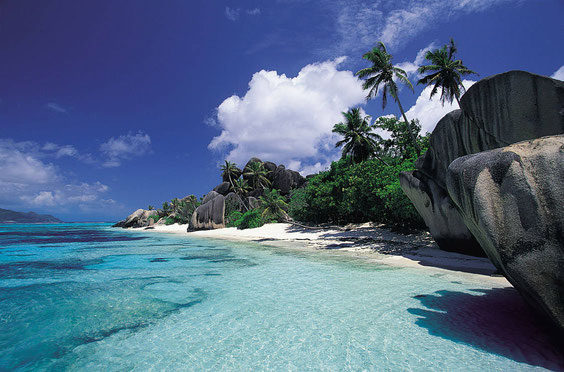
#1 Source d'Argent Beach, La Digue, Seychelles
Di seguito una mia personalissima classifica sulle 10 spiaggie più belle al mondo...impresa ardua e riduttiva che vuole solamente rendere un tributo ad alcune delle perle protette e a volte meno conosciute a molti. Ho dovuto rinunciare a parlare di molte delle spiaggie che ritengo bellissime, visitate e non, ci saranno altre occasioni per parlarne.
Following my very personal ranking of the 10 most beautiful beaches in the world...a difficult and very simplistic task with which i just want to pay tribute to some of the protected and sometimes maybe unknown to the majority ones. I had to waive talking about many of those i consider beautiful, visited or not, i will have other occasions to talk about.
- L'isola più conosciuta dell'arcipelago a nord del Madagascar deve la sua notorietà agli splendidi contrasti creati dalle rocce di granito con la sabbia bianca, il mare azzurro e la vegetazione lussureggiante.
- The most famous beach north of Madagascar archipelago owes its fame to the astonishing contrasts created by the rocks of granite with the white sand, crystal clear sea and lush vegetation.
"Quante strade deve percorrere un uomo prima che lo puoi chiamare uomo?"
"How many roads must a man walk down, before you call him a man?"
Bob Dylan
VFN Kathmandu children:

www.flickr.com
|